.png.6dd3056f38e93712a18d153891e8e0fc.png.1dbd1e5f05de09e66333e631e3342b83.png.933f4dc78ef5a5d2971934bd41ead8a1.png)
Search the Community
Showing results for tags 'google maps'.
Found 5 results
-
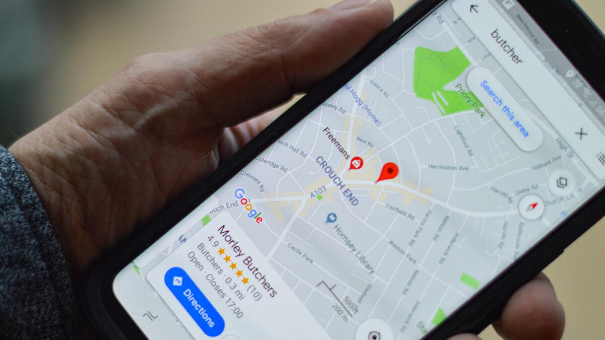
 It looks like Google Maps is getting a cool new feature that’ll make use of generative AI to help you explore your town - grouping different locations to make it easier to find restaurants, specific shops, and cafes. In other words, no more sitting around and mulling over where you want to go today! Android Authority did an APK teardown (which basically means decompiling binary code within a program into a programming language that can be read normally) which hints at some new features on the horizon. The code within the Google Maps beta included mention of generative AI, which led Android Authority to Google Labs. If you’re unfamiliar with Google Labs, it’s a platform where users can experiment with Google’s current in-development tools and AI projects, like Gemini Chrome extensions and music ‘Time Travel’. So, what exactly is this new feature that has me so excited? Say you’re really craving a sweet treat. Instead of going back to your regular stop or simply Googling ‘sweet treats near me’, you’ll be able to ask Google Maps for exactly what you’re looking for and the app will give you suggestions for nearby places that offer it. Naturally, it will also provide you with pictures, ratings, and reviews from other users that you can use to make a decision. Sweet treat treasure hunter I absolutely love the idea and I really hope we get to see the feature come to life as someone who has a habit of going to the same places over and over again because I either don’t know any alternatives or just haven’t discovered other parts of my city. The new feature has the potential to offer a serious upgrade to Google Maps’ more specific location search abilities, beyond simply typing in the name of the shop you want or selecting a vague group like ‘Restaurants’ as you can currently. You’ll be able to see your results into categories, and if you want more in-depth recommendations you can ask follow-up questions to narrow down your search - much in the same way that AI assistants like Microsoft Copilot can ‘remember’ your previous chat history to provide more context-sensitive results. I often find myself craving a little cake or a delicious cookie, so if I want that specific treat I can specify to the app what I’m craving and get a personalized list of reviewed recommendations. We’re yet to find out when exactly to expect this new feature, and without an official announcement, we can’t be 100% certain that it will ever make a public release. However, I’m sure it would be a very popular addition to Google Maps, and I can’t wait to discover new places in my town with the help of an AI navigator. You might also like... Your phone is killing the planet – here are 3 ways to reduce your impactSustainability week 2024A huge Meta AI update finally arrives on Ray-Ban Meta smart glasses... for some View the full article
-
Recent leaks claim Google is working on further integrating satellite connectivity to their Pixel phones and could introduce support for the tech in Google Maps. This information comes from two industry insiders: AssembleDebug who shared his findings with PiunikaWeb and Nail Sadykov over on Telegram. Beginning with the former, users will apparently be able to share their location with others via satellite connection. Hints of the location-sharing tool were found in the strings of code on the latest Google Maps beta. It’s unknown exactly how it’ll work. The report doesn’t go into detail. They do, however, say people “will be able to update their location” in the app every 15 minutes to maintain accuracy. But there’s a catch – you can only refresh your whereabouts “up to five times a day.” It makes sense why Google would implement some sort of restrictions. This is supposed to be an emergency, potentially life-saving feature akin to Emergency SOS on the iPhone and Google may not want people messing around with it. Setting up a satellite connection As for the other update, Nail Sadykov states he found evidence of something called the Android Satellite Pointing UI. It appears to be a help guide for Pixel that’ll teach people how to connect their smartphone to an orbiting satellite. A video posted to the unofficial Google News channel on Telegram shows how the process could work. Users will have to hold their phone in front of them and physically move it around to find a satellite. Once found, you’ll need to keep moving the device until a blue satellite icon reaches the middle of an on-screen circle and stays there for several seconds. Holding the icon in place allows the device to establish connection. If you don’t connect, you’ll receive an on-screen message telling you the session failed. (Image credit: Nail Sadykov) Sadykov goes on to say the guide will be a part of the Pixel’s “Adaptive Connectivity Service (ACS) app”. It’s unclear if he meant the currently available feature or if there will be a new app solely for ACS. He says it’ll be possible to minimize the window into a floating widget on the home page so you can continue texting while trying to establish a connection. When it’s all done, Pixel owners can see Satellite SOS running by swiping down on Quick Settings. You’ll also receive a short message in the menu telling you to avoid buildings, trees, and mountains to ensure a clear view of the sky and not interrupt service. Potential arrival date An arrival date for everything you see here is unknown, although both sources believe their respective features will launch on the Pixel 9. The two groups mention a third leak from April 15 about the Pixel 9 series possibly receiving the Samsung Modem 5400 to enable satellite connectivity. The same satellite icon (albeit red) and guide animations from Sadykov’s post were found in the earlier report. PiunikaWeb also mentions seeing the same symbol. So what we’re seeing today could be the fruits of this new labor – at least potentially. Things could always change at the last minute. Be sure to take all this info with a grain of salt. While we have you, check out TechRadar's roundup of the best Pixel phones for 2024. You might also like Google's next foldable could be the Pixel 9 Pro Fold and finally get flagship specsThe Google Pixel 8a leaks twice, hinting at its design, and four color optionsGoogle Maps AI upgrades could solve your EV charging headaches View the full article
-
It’s a big day for Google Maps. First, the 3D buildings layer is rolling out to all Android users after months of waiting. And now we’re learning the app is expanding its eco-friendly features by introducing new ways to find EV charging stations and "lower-carbon travel alternatives”. The former, according to the announcement, aims to help electric vehicle owners map out those long road trips for the summer. First, text summaries will appear in Google Maps describing the exact location of a nearby charging station. The tool utilizes artificial intelligence to take “helpful information from user reviews” to build directions below the name of a charger. As the company explains, you'll see step-by-step instructions telling you to drive down into an underground parking lot, follow the signs, and turn right just before you exit to find a station. The company explains that since it sources from the community, generated summaries are “accurate and up-to-date”. To continue feeding the feature, reviews for charging stations will ask for extra details from the type of plug you used to how long you spent waiting. (Image credit: Google) While driving in your EV, Google Maps will highlight nearby chargers on your car's dashboard display. Indicators provide the name of the station, how many ports are open at a given time, and the ports' charging speeds. Lastly, Google Maps will recommend the best charging locations for people taking multi-stop trips. The suggestions it makes depend on your EV’s battery level. For example, if the car is fully charged, the app will point out stations nearer your destination rather than the ones closer to you. Everything you see here is scheduled to roll out within the coming months, but their availability differs. Review summaries will be available on the mobile app while the charging station indicators and suggestions will be exclusive to vehicles with built-in Google software. (Image credit: Google) Google Search's travel update The other half of the patch will see Google Maps make “public transit or walking suggestions” below driving routes – so long as travel times are “practical.” It won’t recommend you hop on a bus if it takes longer to go from point A to point B. This feature is receiving a limited rollout as it’s only being released for around 15 cities around the world including London, Paris, and Sydney. (Image credit: Google) Google Search is also getting a travel-centric update. The search engine began adding information for long-distance train routes into results back in 2022. Moving forward, these details will include schedules and ticket prices with a purchase link on the side. What’s more, long-distance bus routes are going to be present too. The new train data on Search is now available across 38 countries such as the US, UK, Australia, Canada, and Spain. The bus route info, on the other hand, is seeing a more limited release as it'll only show up in 15 global regions, including the United States, France, and Germany. Be sure to check out TechRadar's list of the 10 things you didn't know Google Maps could do if you want to learn about all the neat tricks. You might also like Google Maps could soon get better at knowing which direction you're facingGoogle Maps just got some big travel upgrades – including much-improved listsFeeling lost in the concrete jungles of the world? Fear not, Google Maps introduces a new feature to help you find entrances and exits View the full article
-
 Google today announced several changes that it is making to the Google Maps platform, including an AI update. Google Maps now provides better at-a-glance information on locations, with the details powered by Google AI. Maps shows photo highlights and reviews that summarize what people like about a location. A restaurant's food items can be identified using AI, and Google Maps will also provide cost, potential availability, and whether or not it caters to dietary restrictions. Google says that it will now be easier to discover helpful recommendation lists from top sites and the Google Maps community in select cities in the U.S. and Canada. To use the feature, search for a city and swipe to see curated lists of recommendations from people familiar with the city. There are also Trending, Top, and Gems lists that highlight popular locations to visit when traveling. The feature is available in 40 cities this week, with more coming in the future. To go along with the change to recommendations, Google is adding new customization tools for creating lists in Maps. Google Maps users can choose the order that places appear in their created lists to rank them, and there are options to link content from social channels. Google says that the list updates will be rolling out on Android and iOS later this month. Finally, Google Maps users can expect to see a refreshed design that includes a cleaner home screen with fewer tabs and new pin colors that make it easier to find places on the map. This article, "Google Maps Gains New AI Tools, Updated Recommendation Lists and More" first appeared on MacRumors.com Discuss this article in our forums View the full article
 -
 The 2020 holiday season presents a unique opportunity for retailers to showcase their flexibility in adapting to shifting consumer behavior. COVID-19 has transformed how consumers shop and how retailers sell. Favoring convenience, safety, and value, consumers are more open to switching brands. Studies show that 35% of those who experienced problems in the shopping journey are less brand loyal¹. Shoppers follow a non-linear path of online search, optimizing based on product availability, stores nearby, shipping costs, and wait times, before deciding to purchase. As such, retailers are changing their standard operating procedures to match and exceed expectations for cautious consumers. In order to increase conversions and improve bottom line, retailers need to improve the omnichannel experience as customers traverse the shopping journey from online to offline. To start, you can optimize the store locators on your site and checkout flow. We’ve outlined the best practices and APIs you need to build out two retail solutions–Store Locator Plus and Checkout, for your business. Show customers the best store or restaurant to visit Retailers can help expedite the decision making process for consumers, starting with Store Locator Plus–a set of Google Maps Platform APIs that retailers can combine to give users rich contextual information and create a consistent experience across surfaces for the best location to visit. Retailers can show a responsive list of locations, sorted by travel distance or time on a custom-styled map. Shoppers can easily view important information such as services, hours, ratings, and relevant COVID-19 operations details. By integrating familiar Google maps directly into websites, retailers can keep customers on the site and provide a consistent experience between Business Profiles on Google and their own websites. Many customers have already started using Google Maps Platform to deliver premium retail experiences. Swisscom, a leading telecommunications company in Switzerland, took the initial step of implementing a store locator on their site as part of their omnichannel strategy. The store locator boosted Swisscom’s online appointments by 25x. Swisscom’s store locator allows customers to directly book appointments. Argos, a leading retailer in the UK and a subsidiary of Sainsbury’s, transformed their traditional brick-and-mortar businesses and developed state-of-the-art store locators on their website. Shoppers can use the store locator and interactive map on the Argos website to identify the best location to visit. They can also use an inventory checking feature on the product pages to find the nearest store with the items they want to pick up at their convenience. By migrating to Google Maps Platform, Argos combined online shopping with in-store convenience and effectively reduced the bounce rate on its website by 12%–translating to 4 million visits a year. The Argos store locator displays a number of nearby store locations with important store info from Place details. Simplify checkout and increase sales A faster, easier checkout process can lead to increased conversions and customer satisfaction. Google Maps Platform’s Checkout solution is a set of recommended APIs that will help both retailers and users validate addresses for accuracy when completing forms for billing and fulfillment (pickup or delivery). Place Autocomplete provides a ‘type ahead’ address prediction service, reducing keystrokes and showing suggestions in real-time. After an address is obtained from Place Autocomplete, retailers can also use the Geocoding API to provide quick visual feedback and determine the precise latitude and longitude of the user’s delivery or pickup address (using Place_ID from Place Autocomplete). This can be used to display a map with a movable pin to confirm the delivery or pickup locations. Tokopedia, a leading marketplace platform in Indonesia, improved its address completion rate by 10% since implementing autocomplete prompts in the search bar and address validation on the Tokopedia app. Failed deliveries and wrong addresses are costly. Getting addresses right upstream during the checkout flow helps accelerate entry, increase conversions, and ultimately build brand loyalty. Tokopedia’s app validates addresses for accuracy and simplifies checkout with Autocomplete. Reimagine a seamless retail experience We’ve seen that digital hasn’t completely replaced brick-and-mortar. Instead, it has extended the shopping experience. Geospatial services and location intelligence can augment the purchasing journey as consumers seek alternative ways to buy and acquire goods. It’s up to the forward-thinking retailer to capture this opportunity and differentiate itself by creating a seamless journey that wins customer trust. To start building your own store locator and checkout solutions, refer to our best practices guide. For more information on Google Maps Platform, visit our website. ¹ “How has retail customer loyalty fared pre- and post-Covid shutdowns? Not well", August 3, 2020


-
Forum Statistics
43.6k
Total Topics43.2k
Total Posts